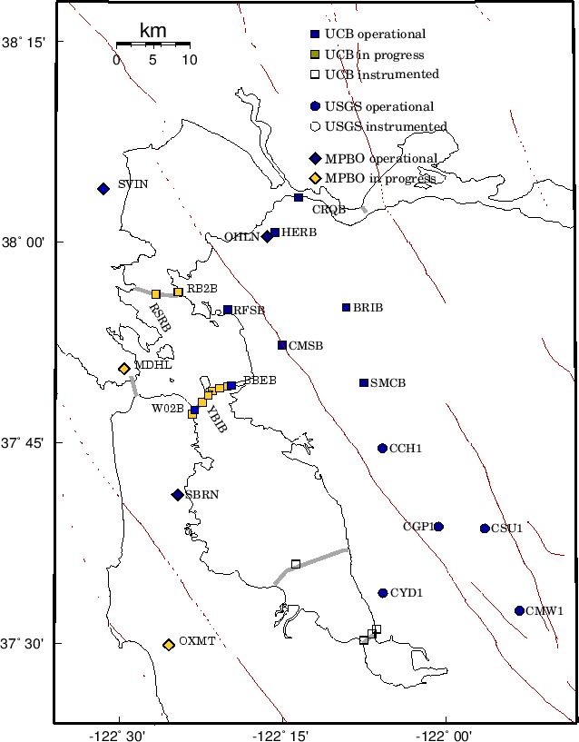
Complementary to the regional broadband network, a deployment of borehole-installed, wide-dynamic range seismographic stations is being established along the Hayward Fault and throughout the San Francisco Bay toll bridges network. This network is a cooperative development of the BSL and the USGS, with support from USGS, Caltrans, EPRI, the University of California Campus/Laboratory Collaboration (CLC) program, LLNL, and LBNL (Figure 4.1 and Table 4.1). Efforts at ongoing development of the network have also recently been enhanced by through coordinated efforts with the Mini-PBO project (Chapter 8, which is partially funded by NSF and by the member institutions of that project).
The purpose of the network is threefold: 1) to lower substantially the
threshold of microearthquake detection, 2) to increase the recorded
bandwidth for events along the Hayward fault, and 3) to obtain bedrock
ground motion signals at the bridges from small earthquakes for
investigating bridge responses to stronger ground motions. A lower
detection threshold increases the resolution of the fault-zone
seismic structure; allows seismologists to monitor the spatial and temporal
evolution of seismicity at magnitudes down to The Hayward Fault Network (HFN) consists of two parts. The Northern Hayward Fault Network (NHFN) is operated by the BSL and currently consists of 25 stations, including those located on Bay Area bridges and at borehole sites of the Mini-PBO (MPBO) project. This network is considered part of the BDSN and uses the network code BK. The Southern Hayward Fault Network (SHFN) is operated by the USGS and currently consists of 5 stations. This network is considered part of the NCSN and uses the network code NC. This chapter is primarily focused on the NHFN and activities associated with the BSL operations.
NHFN OverviewThe five MPBO sites have 3-component borehole geophone packages. All the remaining HFN sites have six-component borehole sensor packages. The packages were designed and fabricated at LBNL's Geophysical Measurement Facility by Don Lippert and Ray Solbau, with the exception of site SFAB. For the HFN sites three channels of acceleration are provided by Wilcoxon 731A piezoelectric accelerometers and three channels of velocity are provided by Oyo HS-1 4.5 Hz geophones. Velocity measurements for the MPBO sites are provided by Mark Products L-22 2 Hz geophones (Table 4.2). Sensors are generally installed at depths of about 100 m, but several sites have sensors emplaced at depths of over 200 m and the Dumbarton bridge sites have sensors at multiple depths (Table 4.1). During initial stages of the project, the NHFN sensors provided signals to on-site Quanterra Q730 and RefTek 72A-07 data loggers. In the current NHFN configuration on-line data logging is being done by on-site Quanterra Q4120 instrumentation. The SHFN sensors have been providing signals to Nanometrics HRD24 data loggers since initiation of data collection. The 0.1-400 Hz Wilcoxon accelerometers have lower self-noise than the geophones above about 25-30 Hz, and remain on scale and linear to 0.5 g. In tests performed in the Byerly vault at UC Berkeley, the Wilcoxon is considerably quieter than the FBA-23 at all periods, and is almost as quiet as the STS-2 between 1 and 50 Hz. Thirteen of the NHFN sites have Quanterra data loggers with continuous telemetry to the BSL. Similar to BDSN sites, these stations are capable of on-site recording and local storage of all data for more than one day and have batteries to provide backup power. Signals from these stations are digitized at a variety of data rates up to 500 Hz at 24-bit resolution (Table 4.3). In contrast to the BDSN implementation, the NHFN data loggers employ casual FIR filters at high data rates and acausal FIR filters at lower data rates. Because of limitations in telemetry bandwidth and disk storage, these 13 sites transmit triggered data at 500 sps, using the Murdock, Hutt, and Halbert (MHH) event detection algorithm (Murdock and Hutt, 1983), and continuous data at reduced rates (100, 20 and 1 sps) to the BSL. The remaining 12 sites of the NHFN have in the past recorded data using RefTek data loggers. These sites do not have continuous telemetry for acquisition and required visits from BSL staff for data recovery. Collection of data from these sites has been discontinued, but efforts are underway to upgraded them with Quanterra Q4120 data loggers and continuous telemetry. Signals from the 5 SHFN stations are digitized by Nanometrics data loggers at 100 sps and transmit continuous data to Menlo Park by radio. These digital data streams are processed by the Earthworm system with the NCSN data and waveforms are saved when the Earthworm detects an event.
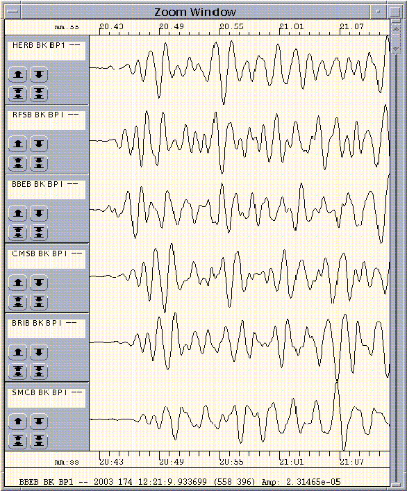
Experience has shown that the MHH detector does not provide uniform triggering across the NHFN on the smallest events of interest. In order to insure the recovery of 500 sps data for these earthquakes, a central-site controller has recently been implemented at the BSL using the 500 sps vertical component geophone data for event detection. Originally the 100 sps vertical component geophone data was used for event detection but the bandwidth proved to be inadequate for detection of the smaller events where most of the seismic wave energy was at frequencies above 40 Hz. Triggers from this controller are being used to recover the 500 sps data from the NHFN data loggers. Data from the NHFN and SHFN are archived at the NCEDC. At this time, the tools are not in place to archive the Hayward fault data together. The NHFN data are archived with the BDSN data, while the SHFN are archived with the NCSN data (Chapter 11). However, the new central-site controller will provide the capability to both include SHFN data in the event detection and extract SHFN waveforms for these events in the future. As originally planned, the Hayward Fault Network was to consist of 24 to 30 stations, 12-15 each north and south of San Leandro, managed respectively by UCB and USGS. This is not happening quickly, although west of the fault, Caltrans has provided sites along the Bay bridges. This important contribution to the Hayward Fault Network has doubled the number of sites with instrumentation. At times, Caltrans provides holes of opportunity away from the bridges (e.g., HERB), so we have plans for additional stations that will bring the network geometry to a more effective state for imaging and real-time monitoring of the fault. As a check on the calibration and an example of the capabilities of a borehole installed network, we compare the bandpass filtered (0.3-2 Hz) ground velocity data recorded at HERB, RFSB, BBEB, CMSB, BRIB, and SMCB for a M 6.9 deep focus teleseism that occurred in the vicinity of the Rat Islands in the Aleutian Islands chain at a depth of 685 km. in Figure 4.2.
2002-2003 ActivitiesIn addition to routine maintenance, operations and data collection; activities of the NHFN project over the past year have also included numerous efforts at network expansion, quality assurance, performance enhancement and catalog development.
Station MaintenanceShown in Figure 4.3 are power spectral density (PSD) distributions of background noise for a sample of 8 NHFN land and bridge site stations. In general, background noise levels of the borehole HFN stations is more variable and generally higher than that of the Parkfield HRSN borehole stations (Figure 5.3). This is due in large part to the significantly greater level of cultural noise in the Bay Area, and to the fact that noise reduction efforts on the much more recently installed NHFN stations are still underway. For example the two noisiest stations (i.e. BBEB and W02) are located on the Bay Bridge which is currently undergoing earthquake retrofit and east span reconstruction. These stations have also only recently come back on-line with upgraded infrastructure and instrumentation, so the full complement of noise reduction modifications have not yet been completed.
On average the MPBO NHFN sites are more consistent and quieter (Figure 8.6). This is due in large part to the greater depth of the MPBO sensors, the locations of MPBO stations in regions of generally less industrial and other cultural noise sources, and possibly to the absence of powered sensors (i.e. accelerometers) in their borehole sensor packages. One of the most pervasive problems at NHFN stations equipped with the new Q4120 data loggers is power line noise (60 Hz and its harmonics at 120, 180, and 240 Hz). This noise reduces the sensitivity of the MHH detectors. Whenever a NHFN station is visited, the engineer at the site and a seismologist at the BSL work together to expedite the testing process, especially when attempting to identify and correct ground-loop faults which generally induce significant 60, 120, 180, and 240 Hz seismic signal contamination due to stray power line signal pickup, generally inductively coupled and aggravated by the presence of ground loops. Below is a synopsis of maintenance efforts performed over the past year for several NHFN stations that gives some idea of the ongoing maintenance and performance enhancing measures that we are continuing to implement.
NHFN Station Maintenance SynopsisBBEB: Installed upgraded power system in July. Installed Q4120 data logger and started data acquisition on September 10, 2002. Replaced coaxial cable and connector between Cylink radio and antenna to fix problem with poor data flow.BRIB: Vault flooded in December during heavy rains owing to failure of sump pump. A portable electric generator and sump pump were used to pump out the water. Wood platforms were installed to raise the batteries off of the floor so that they will not become submerged if the vault floods again. The Rule 2000 Sump pump, Sure Bail switch, associated wiring and battery were repaired in the lab and reinstalled in the vault. CMSB: Replaced batteries with two new C & D Technologies UPS 12-310 batteries. Replaced Q4120 data logger and FRAD. Rodents had chewed on the data logger case but they did not penetrate the case. Replaced defective rodent repeller near the FRAD and installed a second repeller near the data logger. Replaced preamp when it was discovered that channel 4 was bad. Upgraded Q4120 with installation of Q730PWR board. Experienced some problems during year with clock quality owing to poor antenna sky visibility. CRQB: Upgraded Q4120 data logger with installation of Q730PWR board. Disconnect DAT to fix multiple boot up messages and questionable EP counts problem when booting up the Q4120 data logger. The DAT drive is not used so this is not a problem. HERB: Swapped in a new preamp to fix a channel gain problem. Spent some time troubleshooting problem with 60 Hz and its harmonics contaminating geophone channels and running a series of experiments and discovered that the 120 Hz signal is a 100 kHz spike which repeats at a 120 Hz rate. Installed damping resistor when it was discovered to be missing. Also installed shunt capacitors to reduce the high frequency spike noise. Replaced power supply when it was discovered to have periods of imperfect regulation. RFSB: Upgraded Q4120 data logger with installation of Q730PWR board and new software. SMCB: Station was down from August 28 through October 29 owing to construction at Moore Hall which provided power and telemetry. Q4120 digitizers failed due to a blown fuse. While Q4120 was in lab for fuse replacement a Q730PWR board was added to give input power monitoring capability. W02B: Installed hardware (data logger, etc.) in utility boxes bolted to the NW face of the pier, just above water level. Began data acquisition and telemetry on June 17th.
Geophone CalibrationsComparisons of the inferred ground accelerations generated by local earthquakes, from co-sited HFN geophone and accelerometer pairs, shows that the waveforms generally are quite coherent in frequency and phase response but that their inferred ground accelerations differ significantly. At times the amplitudes differ by up to a factor of 2 while the times of the peak amplitudes are identical. This implies that the free period and damping of the geophones are well characterized and also that the generator constant is not accurate (assuming that the corresponding ground accelerations inferred from the accelerometers are accurate).Generally speaking, the accelerometers, being an active device, are more accurate and also more stable that the geophones so it is reasonable to assume that the most likely reason for the difference is that the assumed generator constants for the geophones are not accurate. Rodgers et al. (1995) describe a way to absolutely calibrate the geophones in situ and to determine their generator constant, free period and fraction of critical damping. The only external parameter that is required is the value of the geophones inertial mass. We have built a calibration test box which allows us to routinely perform the testing described by Rodgers et al. whenever site visits are made. The box drives the signal coil with a known current step and rapidly switches the signal coil between the current source and the data logger input. From this information, expected and actual sensor response characteristics can be compared and corrections applied. Also, changes in the sensor response over time can be evaluated so that adjustments can be made and pathologies arising in the sensors due to age can be identified. Once a geophone is absolutely calibrated, we can also check the response of the corresponding accelerometer. We are now performing the initial calibration tests and response adjustments for all NHFN stations as sites are visited for routine maintenance. We also plan a scheduled re-tests of all sites to monitor for sensor responses changes through time.
Combined CatalogWe are building a HF-specific data archive from the existing waveform data that have been collected by the heterogeneous set of recording systems in operation along the Hayward fault (i.e. the NHFN, SHFN, NCSN, and BDSN continuous and triggered waveforms). Recently we have taken the NHFN triggers collected during operations between 1995.248 and 1998.365 (recorded on portable RefTek recorders) and origin times from the NCSN and BDSN catalogs for this time period and undertaken a massive association of event and trigger times. The purpose of the effort is to compile a relatively uniform catalog of seismic data to low magnitudes and extending back in time to the beginning of reliable HFN data collection. The process has reduced nearly a million individual time segments to 316 real events along the Hayward fault during the period-an increase in the number of events of a factor of about 2.5 to 3 over the NCSN catalog alone in the same area.
Event DetectionAs noted in the Introduction, one of the purposes of the HFN is to lower the threshold of microearthquake detection. Towards this goal, we have been developing new algorithms: a pattern recognition approach to identify small events; a phase onset time detector with sub-sample timing resolution, and; a phase coherency method for single component identification of highly similar events.
Pattern RecognitionIn order to improve the detection and analysis of small events (down toThe pattern recognition method is CPU intensive, however, and it will require a dedicated computer to handle the pattern recognition tasks. To expedite the auto-correlation processing of the master pattern, an integer arithmetic cross-correlation algorithm has been developed which speeds up the requisite processing by an order of magnitude.
Phase Onset Time DetectionThe phase onset time detector makes use of the concept that the complex spectral phase data, over the bandwidth of interest (i.e., where the SNR is sufficiently high), will sum to a minimum at the onset of an impulsive P-wave. The algorithm searches for the minimum phase time via phase shifting in the complex frequency domain over the bandwidth where the SNR is above 30 dB, say, to identify the onset time of the seismic phase. The algorithm requires that the recorded waveforms be deconvolved to absolute ground displacement. This implicitly requires that any acausality in the anti-aliasing filtration chain, such as the FIR filters used in the BDSN Quanterra data loggers, be removed. The algorithm typically resolves P-wave onset times to one-fiftieth of the sample interval or better.
Phase Coherency
A spectral phase coherency algorithm was developed to facilitate high
resolution quantification of the similarities and differences between
highly similar Hayward fault events which occur months to years
apart. The resolution of the complex spectral phase coherency methodology is
an order of magnitude better that the cross correlation method which is
commonly used to identify highly similar events with resolution of
order a few meters. This method, originally developed using NHFN borehole
data, is now being applied as well to data from another borehole network (the
HRSN) to provide more rapid and objective identification of the large fraction (
approx. 40
New InstallationsSan Francisco-Oakland Bay BridgeThe infrastructure at seven stations along the San Francisco-Oakland Bay Bridge (SFAB, W02B, W05B, YBAB, E07B, E17B, and BBEB) was upgraded with the installation of weatherproof boxes, power, and telemetry in anticipation of installing Q4120 data loggers and telemetering the data back to Berkeley. BBEB was brought on-line in May of 2002, and W02B in June of 2003.
Land SitesAgreements with Caltrans and St. Mary's college have been made to replace the post hole installation at St. Mary's college (SMCB) with a deep borehole installation. The hole is to be drilled by Caltrans as a hole of opportunity when the schedule of a Caltrans drilling crew has an opening. The site has been reviewed by UCB, Caltrans and St. Mary's college personnel, and we are now in the drilling queue. Depending on the geology at borehole depth, this site my either become a MPBO site (w/o accelerometers) or a standard land site installation including both geophones and accelerometers.Caltrans has also provided funding for instrumentation of several other land sites which we will install as future Caltrans drill time becomes available. Currently we are considering sites for these additional holes-of-opportunity at Pt. Pinole, on Wildcat Mtn. in the north Bay.
Mini-PBOThe stations of the Mini-PBO project (Chapter 8) are equipped with borehole seismometers. As these stations have become operational, they augment HFN coverage (Figure 4.1). In the last year, SVIN and SBRN have added coverage to the north bay and east side of the south bay, respectively.
AcknowledgementsThomas V. McEvilly, who passed away in February 2002, was instrumental in developing the Hayward Fault Network, and without his dedication and hard work the creation and continued operation of the NHFN would not have been possible.Under Bob Nadeau's, Bob Uhrhammer's and Doug Dreger's general supervision, Rich Clymer, Wade Johnson, Doug Neuhauser, Bill Karavas, John Friday, and Dave Rapkin all contribute to the operation of the NHFN. Bob Nadeau, Bob Uhrhammer and Lind Gee contributed to the preparation of this chapter. Partial support for the NHFN is provided by the USGS through the NEHRP external grant program. Expansion of the NHFN has been made possible through generous funding from Caltrans, with the assistance of Pat Hipley. Larry Hutchings of LLNL has been an important collaborator on the project.
ReferencesRogers, P.W., A.J. Martin, M.C. Robertson, M.M. Hsu, and D.B. Harris, Signal-Coil Calibration of Electromagnetic Seismometers, Bull. Seism. Soc. Am., 85(3), 845-850, 1995. Murdock, J., and C. Hutt, A new event detector designed for the Seismic Research Observatories, USGS Open-File-Report 83-0785, 39 pp., 1983.
|


Green Reading | What to do in the Event of a Nuclear Accident | Dosimeters
Plutonium | Particle Physics | Disposal

FindLaw Firms Online -- 11222 Web Sites for the Legal Community.
New! Robots for Geologists | Friends | Home Preparation
Area Geology | Public Health | If It Rains Robotics for Geology